Unoffical empeg BBS

Quick Links: Empeg FAQ | RioCar.Org | Hijack | BigDisk Builder | jEmplode | emphatic
Repairs: Repairs

Topic Options
#351859 - 27/04/2012 20:48 Looking for a mapping tool
Dignan
carpal tunnel

Registered: 08/03/2000
Posts: 12318
Loc: Sterling, VA
I'm trying to find a mapping tool. Basically, I want to be able to chose several points on a map, chart a driving radius from each point based on time, then see where they all overlap.

Can anyone find a tool that does this?

So far I've found the following sites:

Drivingradius.com - Interesting, but does not calculate based on time at all, and doesn't seem to do multiple points. If you're looking to calculate distance, it looks great. It gives a perfect circle around a point to show a radius as the crow flies, and then also plots out how far from that point you can get by road. It's neat and works just how they made it, it's just not what I'm looking for.

How Far Can I Travel - Kind of close. The main problem is that it can't do multiple points. It will calculate how far from a point you can drive in a certain amount of time, but the problem is that it won't account for road speed. A 25mph neighborhood is given equal consideration to a four lane highway. The controls I'm given to adjust for this are very imprecise. Therefore I don't really trust the results.

That's all I've stumbled across so far. I feel like there should be a Google Earth plugin for this. Google knows how fast different roads are, don't they? I'm surprised that second site doesn't use that, unless the API doesn't give them access...
_________________________
Matt

Top
#351875 - 28/04/2012 17:08 Re: Looking for a mapping tool [Re: Dignan]
wfaulk
carpal tunnel

Registered: 25/12/2000
Posts: 16706
Loc: Raleigh, NC US
You're trying to find a center between three locations? Like find a meeting point between three people so that they all have to travel the same amount of time?

I don't know anything like this. I'm just trying to clarify the question.
_________________________
Bitt Faulk

Top
#351877 - 28/04/2012 22:23 Re: Looking for a mapping tool [Re: wfaulk]
Dignan
carpal tunnel

Registered: 08/03/2000
Posts: 12318
Loc: Sterling, VA
Originally Posted By: wfaulk
You're trying to find a center between three locations? Like find a meeting point between three people so that they all have to travel the same amount of time?

Sort of, but I'm not looking for one point, I'm looking for an area.

Actually, I've kind of found a solution using that second link in my initial post. I'm still skeptical of the results that site produces, and how it calculates drive time, and there are other problems with its output, but I have a rough result that's somewhat acceptable.

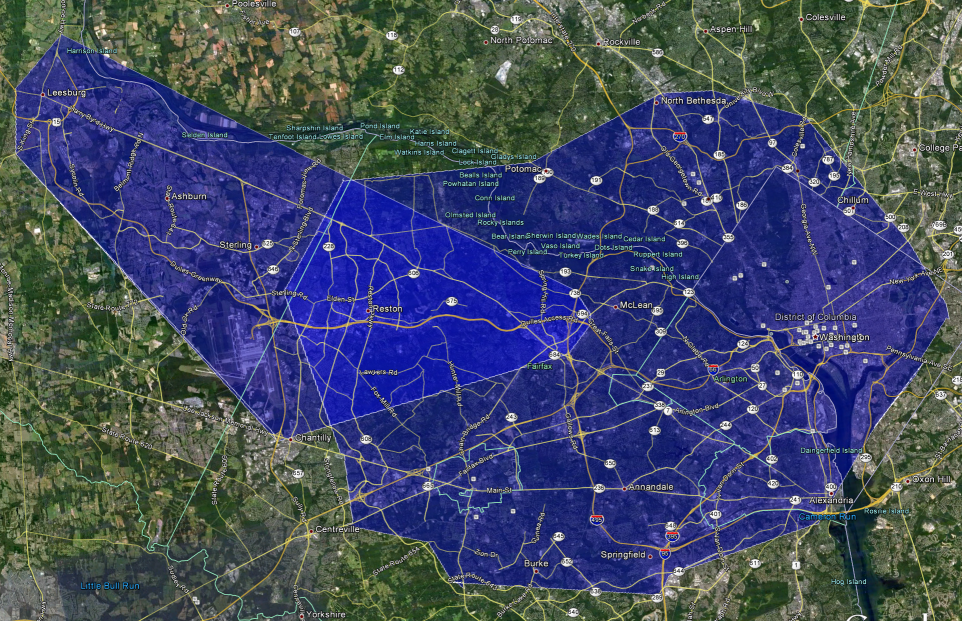
Basically, I ran one address through that "How Far Can I Travel" site and exported the resulting KML file. I then did that for my second point. Then, I was able to load both files into Google Earth and find an overlap. I've attached a screenshot of the result.

The problem is that because one of the two addresses is within about 10 miles from the Potomac River, there's no way anyone could drive to the other side of that river in 30 minutes given how the bridges are spaced*, so the area is skewed and doesn't go up far enough.

But mostly I'm not satisfied with the results that site gives...


*it's surprisingly far between the American Legion Bridge, which connects MD and VA on the beltway, and the next bridge west at Point of Rocks. About 29 miles as the crow flies. In between there's a ferry, still pretty far out.


Attachments
overlap001.png (246 downloads)

_________________________
Matt

Top
#351878 - 29/04/2012 01:00 Re: Looking for a mapping tool [Re: Dignan]
hybrid8
carpal tunnel

Registered: 12/11/2001
Posts: 7738
Loc: Toronto, CANADA
I think if you develop the solution yourself you could probably make some decent money selling access to it. A lot of specialized cartographic-driven software runs big bucks.
_________________________
Bruno
Twisted Melon : Fine Mac OS Software

Top